
Plants & Fire in Azusa
- Kevin Shin
- Mar 28, 2022
- 6 min read
Santa Fe Dam to the base of the San Gabriel Mountains
Overview
Learn about some plants along this stretch that passes through Irwindale, Duarte and Azusa. At the turnaround point, we have some views of late August 2020 fire damage, so we'll explore the topic of fire ecology.
This route can be best explored with bikes that can handle some gravel terrain, but it can be avoided or contained to very short stretches if necessary.
This 11.1 mile ride starts at Santa Fe Dam Recreational Area and heads North along the San Gabriel River Bike Path, providing a view of the San Gabriel Mountains for the first half of your ride. The ride back offers views of the hills that make up Hacienda Heights, Rowland Heights and other communities. The route is mostly on a Class 1 bike path, meaning it's separated from traffic. However, there is a short stretch where the path is unprotected and runs alongside San Gabriel Canyon Road. There are also two stop signs along the bike path where traffic doesn't have a stop with cars often turning left, but when the route was scouted, drivers seem to be considerate and aware. There is also some road maneuvering if you take the detour to Encanto Park.
There's little to no shade along the route, so bring plenty of water and sunscreen. There are restrooms at Santa Fe Dam and at Encanto Park, which is 1.6 miles from the start and 3 miles from the turnaround point, so you can visit Encanto Park on your way up or on your way down.
This route also offers a view of some of the aftermath of the recent fires in the area, offering an opportunity to learn about fire ecology in Southern California.
There is a $12 vehicle entrance to Santa Fe Dam and they currently take cash or card. Bike entrance is free. There isn't much parking nearby. The closest transit station is Irwindale Gold Line Station, although there is no bike infrastructure connecting the station to the beginning location. Public transit users should be aware that the 2.7 mile section heading South on Irwindale Avenue then West on Arrow Hwy is for experienced riders confident with sharing a lane with traffic and taking the lane when necessary.
Entrance to Santa Fe Dam
If you'd rather avoid entering the Dam altogether, you can head to Encanto Park (751 Encanto Pkwy, Duarte, CA 91010) instead and connect to the San Gabriel River Path from there.
After entering the Santa Fe Dam recreation area, head straight and park in that first lot if you can. From there, there's a gravel path that leads you along bumpy terrain for a few feet before joining the San Gabriel River bike path.
This first part immerses you quickly into the native plants of Southern California that you'll find on either side of this route along the San Gabriel River.


Sandy Trail & Gravel Path to Start
You'll find the sandy trail that connects to the bike path by going to the Northwest corner of the parking lot. There, you'll spot a few different gravel and sand trails. Keep an eye out for the sandy trail that has a bountiful grouping of prickly pear cacti to its right.

Viewing it from the parking lot, it's the trail that is between a tree and a green post (see pic). Heading North along this path will connect you to the paved San Gabriel River Bike Path.
Take some time to observe the prickly pear cactus. With its flat broad green pads and purple-red fruit, the prickly pear cactus is an edible plant native to Southern California. Different varieties of this plant are an important food source for indigenous people in parts of the United States, Mexico and Central and South America. Don't touch it tho - the plants are covered in spines and tiny barbed hairs that will cause you a world of pain. Admire from afar. To get a taste of them, it'd be better to visit a Latin American restaurant or supermarket and ask around. The flat green pads can be boiled, sautéed, grilled, pickled or eaten raw. Prickly pears can be made into jams or a refreshing juice.

The gravel and sand soon makes way to a paved path, but keep an eye out for potholes along this stretch.

The Bike Path Begins!
At our first stop sign, head straight to continue onto the bike path. To the right you'll see where the path from the Santa Fe Dam entrance connects. You'll also see the Santa Fe Dam Nature Center, which is temporarily closed.
This is where we first become acquainted with a variety of unassuming but incredible plants. The California buckwheat is native to the southwestern United States and northwestern Mexico. The small seeds and young shoots of the plant are edible. The leaves are traditionally used to line granaries to keep acorns dry. It's also considered a keystone species, meaning that without it, the sagebrush scrub ecosystem which it is a part of would drastically change. In this case, it's because wildlife and butterflies heavily depend on it.
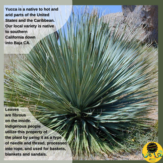
You'll also see a lot of Yucca along this ride. Yucca is a native to hot and arid parts of the United States and the Caribbean. Our local variety, known as the chaparral yucca (or Hesperoyucca whipplei if you wanna go Latin) is native to southern California down into Baja California in Mexico. The leaves - those pointed needles you want to stay away from - are fibrous on the inside. Indigenous people utilize this property of the plant by using it as a type of needle and thread, processed into rope, and used for baskets, blankets and sandals. See if you can spot Yucca at different life stages along your ride. Yucca that has flowered and dried up looks very different from the Yucca in this picture. See if you can a Yucca with a tower of white flowers growing out of the middle. These flowers are edible at different stages of their growth cycle, each with its own preparation method. Can you spot Yuccas with flowers in different stages? (the flowers haven't opened, the white flowers are open and beautiful, or the flowers have given way to seedpods).


Fire Ecology
For centuries, controlled fires were an indigenous practice to steward and manage the lands of Southern California. Socal is a place where fires are nature's way of starting anew, and would naturally occur every 10 to 20 years. Native plants have adopted to this cycle, known as fire ecology. Some native plants in this area can't germinate without fire, such as the Ceanothus. When indigenous stewardship practices were banned in exchange for a policy in favor of extinguishing fires as soon as they happen, allowing natural combustible material to accumulate. The Big Burn of 1910 was affected Idaho, Montana, Washington and British Columbia. It burned three million acres. As a result, in 1935 it became government policy to extinguish all forest fires by 10am the following day.

If combustible material (known as fuel load), is allowed to accumulate (such as when fires don't burn every 10 to 20 years), fire can become huge devastating events with extremely high temperatures. In turn, hot fires with large amounts of fuel can contribute to mudslides.
To make things worse, a fire on a canyon slop (and the San Gabriels have lots of canyons) can cause a super hot fire that spreads quickly due to the chute-like nature of the canyon.
Mixing with Traffic
Coming up is a short stretch where the path is unprotected and runs alongside San Gabriel Canyon Road. There are also two stop signs along the bike path where traffic doesn't have a stop and traffic can make left turns. When the route was scouted, drivers seemed to be considerate and aware. Nevertheless, you are responsible for your own safety. Make sure to come to a complete stop, like in all four directions (front, back, left, right, and left again!), before entering the crosswalk. Soon after this, you'll hit the pretty obvious end of the bike path. Time to turn around and head back!


Path to Encanto Park
To the right is the paved path to Encanto Pkwy. You'll have to transition into traffic for a short stretch in order to get to the park. There are restrooms and a bike repair station with all of the tools still attached! Once back on the San Gabriel River Bike Path, you'll have a view of the hills in the Rowland Heights/Hacienda Heights area to the southeast.


Home Stretch
We're almost back to where we started. Here you can choose to head back to the parking lot via the sand and gravel path we took at the beginning. Or you can take an alternate route to loop up and around to the entrance of Santa Fe Dam. Once you reach the yellow gate you saw on your way in, you can make a right and follow the road back to the parking lot.
